Bisecting Joburg: A Walk on Linksfield Ridge
Last weekend I took a walk through the Harvey Nature Reserve on Linksfield Ridge. Walking on this ridge is an interesting reminder of Joburg’s crazy geological history.

I am obviously not a geologist. But here is my simplistic attempt to explain Joburg’s geology:
Joburg sits on a huge ridge, the Witwatersrand (or “Rand” for short) – a snaking spine about 1800 meters (5900 feet) above sea level, which runs for 56 kilometers (35 miles) from east to west. To see what the Rand looks like from above, check out this fun topographical map.
The earth inside the Witwatersrand was once full of gold, which is why Joburg was built in the first place. It’s a fascinating and scary reason for a city to exist, when you think about it. Humans spent more than a century digging all of the gold out of the ridge, and now the gold has mostly been removed but the ridge is still here and so are the people.
(Given all the messing around beneath the Witwatersrand over the past 130-plus years, I often wonder why the earth hasn’t collapsed and swallowed Joburg up completely. Maybe an actual geologist will chime in and explain this.)
There are a bunch of smaller ridges poking out on top of the Witwatersrand. Linksfield Ridge, which runs east-to-west between the suburbs of Bedfordview and Orange Grove, is one of those.
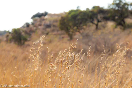
Walking Linksfield Ridge
The Harvey Nature Reserve is on the west side of Linksfield Ridge; the entrance to the reserve is at the end of Kallenbach Drive. Kallenbach Drive was built by the prominent Joburg architect Hermann Kallenbach, who once owned all of Linksfield Ridge and was a close friend of Mahatma Gandhi’s. But I digress – I’ll have to write more about Kallenbach in a future post.
Unfortunately the gate into Harvey Nature Reserve is locked for safety reasons, and can only be accessed by those with a key (a typical Joburgian quirk). I happen to know someone who has a key, which is how Thorsten and I got to walk on Linksfield Ridge last Sunday.
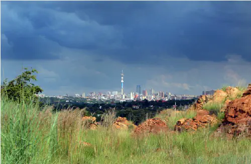
Joburg has many ridges, as I said. But Linksfield Ridge is particularly interesting because it runs perfectly east-west and is right in the middle of town, serving as an unofficial dividing line between central Joburg and the East Rand. As we walked along Linksfield Ridge, it felt like we were bisecting the city, with the downtown skyline on one side and the Sandton skyline on the other.


We walked along the ridge for a little more than two kilometers, then turned around and walked a similar route back. Apparently there is public (unlocked) access to the ridge from the far east end, near Gillooly’s Farm. But the walk is much longer and less pretty from that side.
I look forward to bisecting Joburg again in the near future.

Comments
I used to walk both these Ridges a lot with my old Hiking Group and the views are spectacular. Reaching the Ridge from Gilloollys is tough and the walk long - but it was always worth it.
We’ll have to try it someday!
Did you have to pay or book or can you just go to hike there?
Hi Gabriella, unfortunately the ridge isn’t technically open to the public. You have to find someone who has a key :(
Yes I too always wonder about the city falling into a great big hole. Thanks for the attached map of the ridge, didn’t Fiver want to walk the full distance at one stage?
Hmm, I’m not sure. I she wanted to walk the whole of Main Reef Road.
Oh yes, got a bit confused as they follow the same route.
It would be a long walk!
Hi Heather, you should have popped in for tea (or something :)). I have been follwoing you for years and I actually live on Kallenbach Drive … I also have a number of keys :) … next time.
Hi Bianca, oh wow, that’s so cool! I just might take you up on that…I actually want come back to take some pictures of the pass for another post. I will let you know – thanks :)
Would so love to do Linksfield Ridge again…my Dad who recently passed away used to regularly take us on this hike from Cyreldene to Giloolys Farm when the gate was unlocked. Just need to find someone with a key and was wondering Bianca if you could assist? Would really appreciate it.
I had no idea Joburg was so far above sea level. It all makes sense, and I love the map.
I had no idea either, until the first time I tried to go for a run in Joburg and realized I could barely breathe. Ha! I also love that map – I’m glad this blog post gave me the opportunity to discover it.
My father was (chief) town planner of what became Sandton. When he tried to convince developers that some farmland and riding schools out in the bundu was going to be the next big thing … well that’s all history. Michael Rapp took the gamble and built Sandton City. To see the skyline now (I have not lived there for more than 30 years) is sobering.
It’s not the prettiest skyline, for sure. I’ll take downtown over Sandton any day.
Great post (and those sketches!). I live right near the Gillooly’s access point (Morninghill) and I’ve walked along the ridge heading Linksfield a few times. Gorgeous views of the Jozi skyline but loads of litter - curious if the section you were on was litter-free? Also Gilloolys side isn’t the safest - your route is ideal I suspect. I need keys! ????
The Linksfield side is pristine! I didn’t see any litter at all. We also passed a couple of armed guards patrolling the route. I suspect the neighbors on Kallenbach Drive must pitch in for security and maintenance.